
{{product.productLabel}} {{product.model}}
{{#if product.featureValues}}{{product.productPrice.formattedPrice}} {{#if product.productPrice.priceType === "PRICE_RANGE" }} - {{product.productPrice.formattedPriceMax}} {{/if}}
{{#each product.specData:i}}
{{name}}: {{value}}
{{#i!=(product.specData.length-1)}}
{{/end}}
{{/each}}
{{{product.idpText}}}
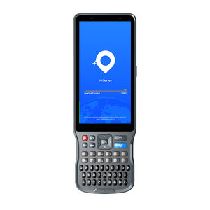
... Hi-Survey 是一款安卓软件,专为各种类型的实地土地测量和道路工程项目而设计。它兼容 Hi-Target 专业控制器、安卓手机、平板电脑和其他第三方安卓设备。它是一款时尚易用的软件,通过内置工具支持大数据操作。通过定制的行业应用解决方案,为用户创造更多可能性。 启动您的高效工作 高效的测量方法。当它与专业的 GNSS 接收机结合使用时,将使您的测量工作变得简单。 准动态测量功能 Hi-Target 自主研发的一种测量方法,可在一些多径干扰强、信号受阻的艰苦地区进行测量,如站在大树旁。 道路工程测量 用于复杂道路的放样、道路线路的组合,具有三种道路算法(交叉、要素、坐标),支持各种道路、共线、多类型复杂线路。 ...
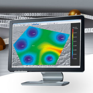
... : 站点评估和质量控制 网络 RTK 性能监测 基准站完整性监测 变形监测 RINEX 数据管理(连接、抽取) 适用于所有 GNSS 基准网络 Leica SpiderQC 以标准 RINEX 格式处理 GPS(包括 L2C 和 L5)、GLONASS、北斗和伽利略(包括 AltBOC)数据,所有领先的基准站软件都支持这种格式。Leica SpiderQC 是所有基准站网络的完美伴侣。它允许网络运营商以高效的方式监控网络质量。与 ...
请说明:
您的建议是我们进步的动力:
剩余字数